Information about KINGS PLAINS National Park
| FACILITIES AVAILABLE IN THIS PARK as known March, 2007" |
  
|

|
| FACILITIES AVAILABLE IN THIS PARK as known March, 2007" |
|
|
|
|
|
|
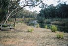
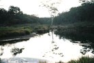
Lying some 48Km to the east of Inverell on the Swanbrook Road, the Kings Palins National Park is an area of Ironbark woodlands. The Kings Plains Creek runs through the park and provides a pleasant change to the surrounding countryside.
The park is ideal for bushwalkers and birdwathchers and contains a large variety of wildflowers and birds. A one hour walk downstream from the picnic area allows the visitor to view the waterfall.

|
Two views of the Kings Plains National Park.
Further photographs of the park are also available. |
|

|
This site is maintained by a group of volunteers. We strive to do our best but sometimes things are overlooked. If you find things that you deem incorrect or if you know of things and links that could enhance this site, which is primarily a dedicated link site containing only basic information, then please EMAIL us (using the button to the right) so that we can include it. All assistance is greatly welcomed.
|

|
|