
| Home | Accommodation | Art & Craft | Business | Community | District Map |
| Education | Entertainment | Events | Eateries | History | Information |
| Local News | Photo Gallery | Real Estate | Sport | Tourism | Local Weather |
This map shows TAMWORTH and its surrounds. Many of the other places on this map are active links to enable you to go straight to that particular place.
For detailed maps in a variety of formats, click the button below and choose which options suit your particular needs.
| Local councils do have some maps of communities located within their boundaries (as well as other information). You can access this information through the Local Council site through the link found on Local Information Section of this site. |

By using the Google Map tools it is possible to gain very accurate scale maps
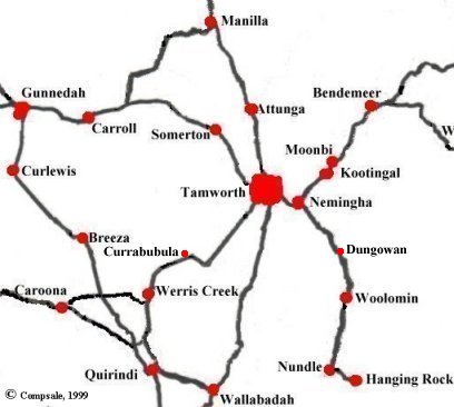
The roads are indicated as links between centres and are not to be taken as to represent the type or quality of the road. People wishing to know this information should obtain proper road maps from motoring authorities or other sources.
The roads are indicated as links between centres and are not to be taken as to represent the type or quality of the road. People wishing to know this information should obtain proper road maps from motoring authorities or other sources.
There is also a DETAILED MAP of the region that shows the basic interconnection and location of most of the cities, towns, villages and communities within the region. This DETAILED MAP has active links to the towns across the region. This map is approximately 250Kb in size and so it may take a little time to load.
|
This site is maintained by a group of volunteers. We strive to do our best but sometimes things are overlooked. If you find things that you deem incorrect or if you know of things and links that could enhance this site, which is primarily a dedicated link site containing only basic information, then please EMAIL us (using the button to the right) so that we can include it. All assistance is greatly welcomed.
|

|
|